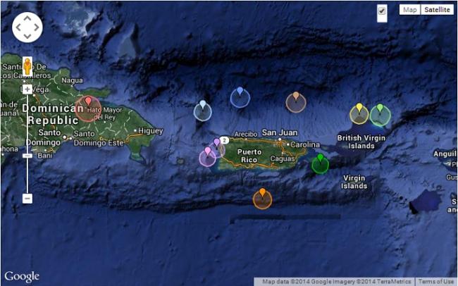
In the past two weeks there have been numerous earthquakes near the Caribbean and Central America region with at least two of those quakes above 5.0 magnitude
On Tuesday February 18, 2014 a strong 6.5-magnitude quake occurred about 100 miles north-northeast of Bridgetown, Barbados and on Friday February 21, 2014, a 5.1-magnitude seismic event occurred near Sanare, Venezuela.
While these quakes did not create much damage, it is a reminder that the Caribbean continues to remain an active earthquake zone.
The largest recent earthquakes to have occurred in this region are (Earthquaketrack.com):
- Today:3.6 magnitude near Sabana Grande de Boyá, Monte Plata, Dominican Republic
- This week: 4.8 near Ríohacha, La Guajira, Colombia
- This month: 6.5 near Bridgetown, Saint Michael, Barbados
- This year: 6.6 near Quibdó, Choco, Colombia
The magnitude 1.5 or greater earthquakes that have occurred in the Caribbean and Central America (Earthquaketrack.com):
- 10 earthquakes today
- 52 earthquakes in the past 7 days
- 270 earthquakes in the past month
- 2,652 earthquakes in the past year
Earthquakes are common in the Caribbean but the recent strong seismic events have awakened the fears of the destructive power of those that wreaked havoc in the area over the last century.
On October 11, 1918, the island of Puerto Rico was struck by a magnitude 7.5 earthquake, centered approximately 15 kilometers off the island’s northwestern coast, in the Mona Passage. In addition to causing widespread destruction across Puerto Rico, the quake generated a medium sized tsunami that produced “run-up” as high as 18 feet along the western coast of the island and killed 40 people, in addition to the 76 people killed by the earthquake.
In 1946 a tsunami triggered by a magnitude 8.1 earthquake off the coast of the Dominican Republic reportedly killed more than 1,600 people.
The more recent 2010 magnitude 7.0 earthquake in Haiti which left more than 100, 000 people dead and catastrophic damage to the already fragile infrastructure, demonstrated the stark reality of the devastation and suffering. All brought to us by modern communications much of which had to be transported to the scene because of the destruction of the local infrastructure.
History of earthquakes in the Caribbean region up to February 2010 (USGS)
- 1692 06 07 – Jamaica Fatalities 2,000
- 1787 05 02 – Puerto Rico – M 8.0
- 1812 03 26 – Caracas, Venezuela – M 7.7 Fatalities 26,000
- 1843 02 08 – Leeward Islands – M 8.3 Fatalities 5,000
- 1867 11 18 – Puerto Rico Region
- 1907 01 14 – Kingston, Jamaica – M 6.5 Fatalities 1,000
- 1918 10 11 – Mona Passage – M 7.5 Fatalities 116
- 1946 08 04 – Samana, Dominican Republic – M 8.0 Fatalities 100
- 1946 08 08 – Samana, Dominican Republic – M 7.6
- 1967 07 29 – Near the Coast of Venezuela – M 6.5
- 1969 12 25 – Guadeloupe, Leeward Islands – M 7.2
- 1974 10 08 – Leeward Islands – M 7.5
- 1997 07 09 – Near Coast of Venezuela – M 7.0
- 2003 09 22 – Dominican Republic Region – M 6.4 Fatalities 3
- 2004 11 21 – Leeward Islands – M 6.3 Fatalities 1
- 2004 12 14 – Cayman Islands Region – M 6.8
- 2006 09 10 – Gulf of Mexico – M 5.8
- 2007 11 29 – Martinique Region, Windward Islands – M 7.4 Fatalities 1
- 2009 09 12 – Offshore Carabobo, Venezuela – M 6.3
- 2010 01 12 – Haiti – M 7.0 Fatalities 316,000
Earthquake Early Warning System
Since 2008, the USGS Earthquake Hazards Program has supported research and development on earthquake early warning in partnership with Caltech, University of California Berkeley, and others, with goals to develop methods that would allow rapid detection of earthquakes in the western United States. The Earthquake early warning can be used to slow and stop trains, alert and protect critical infrastructure, and provide a few seconds for people to take cover
According to University of the West Indies Seismic Research Center there are over 50 stations in the entire network (TRN Network) sending their signals to 13 nodes or sub-networks, (Trinidad, Atlantic LNG, Dominica – 2 separate nodes, Barbados, Grenada, St. Vincent, Saint Lucia, Netherlands Antilles – 3 separate nodes, St. Kitts, Antigua). We hope that there is a concerted effort by the Caribbean governments and all concerned to collaborate with USGS and enhance our seismic research groups. The efforts should provide ample funding for researchers and students who can better understand and develop improved early warning systems that could mitigate the threats by devastating earthquakes and ensuing tsunamis.
According to Grenville Draper Ph,D. Licensed Professional Geologist, State of Florida, earthquakes cannot be predicted but they can be forecasted. During an earthquake, individuals should stand inside a doorframe or underneath a desk or solid piece of furniture to minimize the risk of injury resulting from falling objects. If you are near high-rise buildings and crowded streets, it best to remain indoors to avoid injury from falling plate-glass. If you find yourself in an area with low-buildings and an open square, the safest option is to run outside.
Commenting on earthquakes last January, Draper said “There’s certainly the possibility of a tsunami-generating earthquake occurring in the northern Caribbean. However, such an event would pose a greater danger to the people of the Caribbean and not to us in South Florida,” Draper said. “Tsunamis travel best in deep-water. There are a lot of islands and shallow water between us and the northern Caribbean. Those would dissipate the energy of the tsunami.”
Draper earned a Ph.D. in geology from the University of West Indies. He has studies tectonics and deformation processes in the Earth’s crust, including the behavior of faults and earthquake generation, for more than 30 years. His research is based in the Caribbean, but he has extensive knowledge of the tectonics of South America.


